Decoding the Regulatory API: How Cities Are Programmatically Controlling Autonomous Fleets
Introduction: The Shift to Programmatic City Limits
For decades, cities managed traffic with concrete, paint, and metal signs. But as driverless vehicles flood our streets, a painted “No Left Turn” sign is no longer enough to keep chaotic intersections clear.
Today, municipal leaders are trading physical infrastructure for digital code. Managing dense urban environments now requires real-time, programmatic control—shifting from static roadside warnings to dynamic, API-driven boundaries.
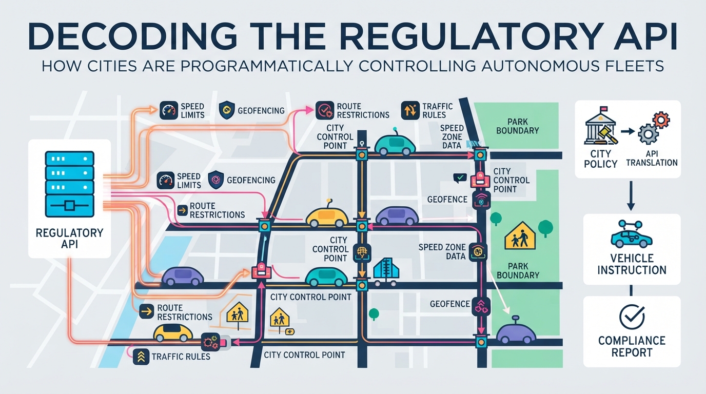
This is where robotaxi regulation tech steps in, redefining modern city planning. By establishing a direct digital link to AV fleet management platforms, cities can now update routing, enforce geofences, and manage curb space instantly.
The shift looks like this:
- Old Way: Physical signs, static speed limits, and manual traffic enforcement.
- New Way: API integrations, dynamic geofencing, and programmatic dispatch control.
Welcome to the era of the programmable city, where code is the new concrete.
Understanding the Mobility Data Specification (MDS) for AVs
To make this digital leap possible, cities needed a universal language. Enter the Mobility Data Specification (MDS).
Originally developed by the Los Angeles Department of Transportation (LADOT) in 2018, MDS was designed to manage the sudden influx of dockless e-scooters and e-bikes. Today, managed by the Open Mobility Foundation (OMF), this open-source digital toolset has evolved far beyond micro-mobility to regulate autonomous vehicle fleets.
Think of the Mobility Data Specification as a standardized, two-way bridge:
- Provider API (Operator to City): AV operators share real-time telemetry, including vehicle status, location, and trip starts.
- Agency API (City to Operator): Municipalities push dynamic regulations, such as temporary road closures, construction zones, and drop-off restrictions.
By translating complex municipal rules into machine-readable code, MDS allows local governments and commercial operators to sync instantly, ensuring autonomous fleets navigate the physical world safely and predictably.

How Two-Way APIs Empower Municipalities
Historically, cities managed traffic through static signs and delayed reports. With modern robotaxi regulation tech, however, municipal data sharing is no longer a passive, one-way rearview mirror.
Instead of just auditing past trips, two-way APIs allow transit agencies to programmatically inject live policies directly into AV routing engines. When a city updates its digital map, the change propagates to the fleet’s dispatch network instantly.
This active orchestration enables immediate, real-time interventions:
- Dynamic Geofencing: Block off streets instantly around active emergency scenes or spontaneous parades.
- Curbside Management: Automatically shift passenger pick-up zones during major stadium events to prevent gridlock.
- Weather-Responsive Limits: Force AVs to lower their speed thresholds during sudden downpours or icy conditions.
By turning data sharing into a real-time remote control, cities ensure autonomous fleets adapt instantly to the living, breathing reality of urban streets.
Policy-as-Code: Turning Speed Limits into Digital Rules
To make this real-time control work, cities must speak the same language as the machines. This is where policy-as-code comes in, transforming dusty municipal codebooks into structured, executable data.
Instead of expecting a self-driving car to read a physical, rusted speed limit sign, cities publish their autonomous vehicle policy directly as JSON or XML files.
Here is how a physical ordinance becomes a digital rule:
1. Translation: Human-written laws (e.g., “no commercial drop-offs on Main St during rush hour”) are converted into conditional logic (If/Then statements).
2. Standardization: Rules are formatted using open data standards like the Mobility Data Specification (MDS) so every fleet operator receives the same instructions.
3. Ingestion: The AV’s routing engine ingests this API payload, instantly updating its behavioral parameters without requiring a software overhaul.
By hardcoding compliance directly into the vehicle’s decision-making engine, cities eliminate the gap between policy creation and street-level enforcement.
Dynamic Geofencing: Creating Real-Time No-Go Zones
Static rules work for predictable traffic, but real-world cities are chaotic. That is where dynamic geofencing enters the frame as a critical piece of robotaxi regulation tech.
Instead of waiting for overnight software updates, cities can draw digital boundaries on a map that take effect instantly. When an emergency strikes or a crowd gathers, the city’s regulatory API pushes a temporary “no-go” zone directly to active fleets.
Here is how cities deploy these real-time boundaries:
- Emergency Response: Instantly rerouting robotaxis two blocks away from active fires or major accidents to clear the way for first responders.
- Spontaneous Events: Carving out temporary exclusion zones around unannounced protest marches or street festivals.
- High-Congestion Mitigation: Restricting pick-ups directly outside a stadium during the peak mass-exodus window of a concert.
Within milliseconds of the API broadcast, the vehicle’s routing engine treats these invisible digital lines with the same authority as a concrete barrier.
Solving the Curb Crisis with Digital Allocation
If geofencing controls where autonomous vehicles (AVs) can drive, digital curb allocation controls where they can stop. The curb is the ultimate urban battleground, but cities are using MDS (Mobility Data Specification) to turn chaotic drop-offs into orderly, programmatic transitions.
Through a dedicated curb management API, municipalities can phase out static metal signs in favor of dynamic, code-driven loading zones. Here is how cities programmatically share the curb:
- Dynamic Time-Slitting: Reserving specific curb space for AV passenger loading during morning rush hour, then shifting it to freight mid-day.
- Micro-Reservations: Requiring robotaxis to secure a 30-second “curb slot” via the API before arriving, eliminating double-parking.
- Demand-Based Routing: Automatically nudging AVs to secondary pick-up zones when the primary curb reaches capacity.
This digital handoff ensures that autonomous fleets never idle in active traffic lanes, turning the curb into a fluid, predictable transit asset.
Addressing Privacy in the Age of Municipal Data Collection
Programmatic coordination requires a constant stream of telemetry data, but tracking every turn of a robotaxi raises immediate red flags. Critics argue that constant GPS-level tracking risks turning municipal data sharing into a tool for surveillance. Striking the right balance is the defining challenge of modern autonomous vehicle policy.
To solve this, cities rely on the Mobility Data Specification (MDS) framework. MDS acts as a privacy shield, stripping away personally identifiable information (PII) before planners ever see it.
Here is how MDS anonymizes trip data in real time:
- Obfuscated Start/End Points: Shifting coordinates by several hundred meters to protect sensitive addresses.
- Aggregated Routing: Bundling individual trips into flow patterns rather than showing unique, traceable routes.
- Delayed Transmission: Introducing a time buffer so live tracking is impossible for compliance audits.
This data-minimization approach keeps rider identities secure while giving cities the macro-level insights they need to optimize transit infrastructure.
Conclusion: The API-First Future of Smart Cities
We are moving toward a future where city streets are no longer static slabs of concrete, but dynamic, self-optimizing ecosystems. By shifting from manual enforcement to code-based compliance, municipalities can manage urban congestion and curb emissions instantly. This shift is redefining AV fleet management from a reactive policy headache into a proactive urban planning tool.
Through standardized robotaxi regulation tech, cities can programmatically adjust transit rules on the fly. Imagine a digital infrastructure that automatically:
- Dynamically prices curb space during peak rush hours to prevent double-parking.
- Re-routes autonomous fleets away from active school zones or emergency scenes in real time.
- Allocates dedicated drop-off zones based on live pedestrian density.
Ultimately, the API-first smart city isn’t about restricting innovation—it’s about orchestrating it. By embedding rules directly into the software that drives these vehicles, cities and fleet operators can co-create safer, cleaner, and infinitely more efficient streets.